
Fel topographic map
Interactive map
Click on the map to display elevation.
About this map
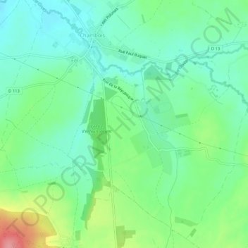
Name: Fel topographic map, elevation, terrain.
Average elevation: 123 m
Minimum elevation: 92 m
Maximum elevation: 195 m
Other topographic maps
Click on a map to view its topography, its elevation and its terrain.
Le Bourg-Saint-Léonard
France > Normandie > Orne > Gouffern en Auge
Le Bourg-Saint-Léonard, Gouffern en Auge, Argentan, Orne, Normandie, France métropolitaine, 61310, France
Average elevation: 168 m
Exmes
France > Normandie > Orne > Gouffern en Auge
Exmes, Gouffern en Auge, Argentan, Orne, Normandie, France métropolitaine, 61310, France
Average elevation: 196 m
Chambois
France > Normandie > Orne > Gouffern en Auge
Chambois, Gouffern en Auge, Argentan, Orne, Normandie, France métropolitaine, 61160, France
Average elevation: 115 m
Urou-et-Crennes
France > Normandie > Orne > Gouffern en Auge
Urou-et-Crennes, Gouffern en Auge, Argentan, Orne, Normandie, France métropolitaine, 61200, France
Average elevation: 184 m
Aubry-en-Exmes
France > Normandie > Orne > Gouffern en Auge
Aubry-en-Exmes, Gouffern en Auge, Argentan, Orne, Normandie, France métropolitaine, 61160, France
Average elevation: 130 m
Silly-en-Gouffern
France > Normandie > Orne > Gouffern en Auge
Silly-en-Gouffern, Gouffern en Auge, Argentan, Orne, Normandie, France métropolitaine, 61310, France
Average elevation: 176 m