
Make a donation
Ucayali topographic map
Click on the map to display elevation.
Make a donation
About this map
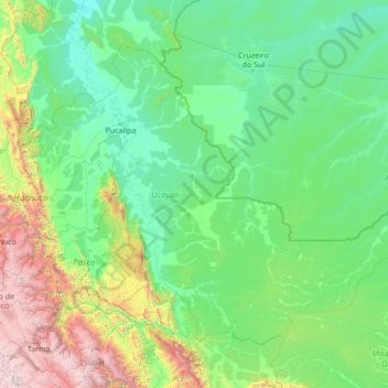
Name: Ucayali topographic map, elevation, terrain.
Location: Ucayali, Peru (-11.44841 -75.94575 -7.26205 -70.49417)
Average elevation: 694 m
Minimum elevation: 115 m
Maximum elevation: 5,617 m
Make a donation
Other topographic maps
Click on a map to view its topography, its elevation and its terrain.
Make a donation
Make a donation
Make a donation
Make a donation
Ausangate
Ausangate or Auzangate (in Hispanicized spellings) is a mountain of the Vilcanota mountain range in the Andes of Peru. With an elevation of 6,384 metres, it is situated around 100 kilometres southeast of Cusco in the Cusco Region, Canchis Province, Pitumarca District, and in the Quispicanchi Province, Ocongate…
Average elevation: 5,617 m
Make a donation
Cerro de Pasco
Peru > Pasco > Cerro de Pasco
Cerro de Pasco is a city in central Peru, located at the top of the Andean mountains. It is the capital of the Pasco region, and an important mining center. At 4,330 metres (14,210 ft) elevation, it is one of the highest cities in the world, and the highest or the second highest city with over 50,000…
Average elevation: 4,239 m
Make a donation