
Thank you for supporting this site ❤️
Make a donation
Make a donation
Rott topographic map
Click on the map to display elevation.
Thank you for supporting this site ❤️
Make a donation
Make a donation
Rott
Die Topographia Ducatus Montani des Erich Philipp Ploennies, Blatt Amt Steinbach, belegt, dass der Wohnplatz bereits 1715 vier Hofstellen besaß, die als Roth beschriftet sind. Carl Friedrich von Wiebeking benennt die Hofschaft auf seiner Charte des Herzogthums Berg 1789 als Roth. Aus ihr geht hervor, dass der Ort zu dieser Zeit Teil der Honschaft Vilkerath im Kirchspiel Overath war.
Thank you for supporting this site ❤️
Make a donation
Make a donation
About this map
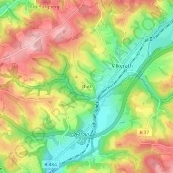
Name: Rott topographic map, elevation, terrain.
Average elevation: 168 m
Minimum elevation: 87 m
Maximum elevation: 260 m
Thank you for supporting this site ❤️
Make a donation
Make a donation
Other topographic maps
Click on a map to view its topography, its elevation and its terrain.
Breidenassel
Deutschland > Nordrhein-Westfalen > Rheinisch-Bergischer Kreis > Overath
Average elevation: 182 m