
Njombe Region topographic map
Interactive map
Click on the map to display elevation.
About this map
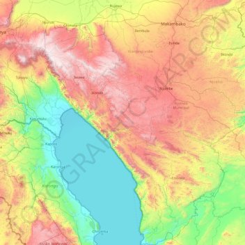
Name: Njombe Region topographic map, elevation, terrain.
Location: Njombe Region, Southern Highlands Zone, Tanzania (-10.54018 33.81174 -8.66511 35.52397)
Average elevation: 1,230 m
Minimum elevation: 328 m
Maximum elevation: 2,955 m
Other topographic maps
Click on a map to view its topography, its elevation and its terrain.
Lupembe
Tanzania > Njombe Region > Lupembe
Lupembe, Njombe, Njombe Region, Southern Highlands Zone, Tanzania
Average elevation: 1,574 m