
Les Vidaux topographic map
Interactive map
Click on the map to display elevation.
About this map
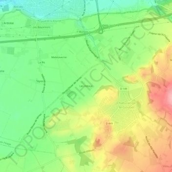
Name: Les Vidaux topographic map, elevation, terrain.
Average elevation: 204 m
Minimum elevation: 149 m
Maximum elevation: 275 m
Other topographic maps
Click on a map to view its topography, its elevation and its terrain.
Pizançon
France > Auvergne-Rhône-Alpes > Drôme > Chatuzange-le-Goubet
Pizançon, Chatuzange-le-Goubet, Valence, Drôme, Auvergne-Rhône-Alpes, France métropolitaine, 26300, France
Average elevation: 170 m