
Thank you for supporting this site ❤️
Make a donation
Make a donation
Kechi topographic map
Click on the map to display elevation.
Thank you for supporting this site ❤️
Make a donation
Make a donation
About this map
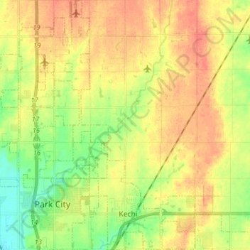
Name: Kechi topographic map, elevation, terrain.
Location: Kechi, Sedgwick County, Kansas, United States (37.78129 -97.32612 37.88288 -97.24482)
Average elevation: 429 m
Minimum elevation: 404 m
Maximum elevation: 449 m
Thank you for supporting this site ❤️
Make a donation
Make a donation
Other topographic maps
Click on a map to view its topography, its elevation and its terrain.
Valley Center
United States > Kansas > Sedgwick County > Valley Center > Valley Center
Average elevation: 415 m