
Thank you for supporting this site ❤️
Make a donation
Make a donation
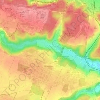
Buc topographic map
Click on the map to display elevation.
Thank you for supporting this site ❤️
Make a donation
Make a donation
Buc
The old town lies in the valley of the River Bièvre at an elevation of around 100 m above sea level. Most of Buc's residential districts have been built on the plateau de Saclay, some 50 m higher.
Thank you for supporting this site ❤️
Make a donation
Make a donation
About this map
Name: Buc topographic map, elevation, terrain.
Average elevation: 151 m
Minimum elevation: 90 m
Maximum elevation: 183 m
Thank you for supporting this site ❤️
Make a donation
Make a donation
Other topographic maps
Click on a map to view its topography, its elevation and its terrain.
Le Champtier des Fourneaux
France > Ile-de-France > Yvelines > Dampierre-en-Yvelines
Average elevation: 143 m
Thank you for supporting this site ❤️
Make a donation
Make a donation
Val des Quatre Pignons
France > Ile-de-France > Yvelines > Beynes > Val des Quatre Pignons
Average elevation: 92 m
Thank you for supporting this site ❤️
Make a donation
Make a donation