
Thank you for supporting this site ❤️
Make a donation
Make a donation
Castromaior topographic map
Click on the map to display elevation.
Thank you for supporting this site ❤️
Make a donation
Make a donation
About this map
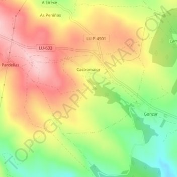
Name: Castromaior topographic map, elevation, terrain.
Location: Castromaior, Portomarín, Lugo, Galice, Espagne (42.82229 -7.72328 42.83598 -7.69742)
Average elevation: 596 m
Minimum elevation: 486 m
Maximum elevation: 692 m
Thank you for supporting this site ❤️
Make a donation
Make a donation