
Make a donation
Semarapura topographic map
Click on the map to display elevation.
Make a donation
About this map
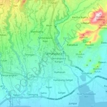
Name: Semarapura topographic map, elevation, terrain.
Average elevation: 113 m
Minimum elevation: 0 m
Maximum elevation: 514 m
Make a donation
Other topographic maps
Click on a map to view its topography, its elevation and its terrain.
Penida Island
Indonesia > Bali > Klungkung Regency > Batukandik
Nusa Penida (Balinese: ᬦᬸᬲᬧᭂᬦᬶᬤ, romanized: Nusa Penida, lit. 'Penida Island') is an island located near the southeastern Indonesian island of Bali and a district of Klungkung Regency that includes the neighbouring small island of Nusa Lembongan and twelve even smaller islands. The Badung…
Average elevation: 104 m
Nusa Lembongan
Indonesia > Bali > Klungkung Regency > Jungutbatu > Jungut Batu
Average elevation: 13 m
Penida Island
Indonesia > Bali > Klungkung Regency > Batukandik
Nusa Penida (Indonesian pronunciation: [nuˈsa pəˈnida]; Balinese: ᬦᬸᬲᬧᭂᬦᬶᬤ, romanized: nusa pĕnida) is an island located near the southeastern Indonesian island of Bali, which forms a district of the same name in Klungkung Regency. The Badung Strait separates the island and Bali. The…
Average elevation: 104 m
Kelingking Beach
Indonesia > Bali > Klungkung Regency > Bunga Mekar > Karangdewa
Average elevation: 76 m
Make a donation
Penida Island
Indonesia > Bali > Klungkung Regency > Batukandik
Nusa Penida (Balinese: ᬦᬸᬲᬧᭂᬦᬶᬤ, romanized: nusa pĕnida) is an island located near the southeastern Indonesian island of Bali, which forms a district of the same name in Klungkung Regency. The Badung Strait separates the island and Bali. The interior of Nusa Penida is hilly with a maximum…
Average elevation: 104 m
Make a donation
Make a donation