
Enterprise topographic map
Interactive map
Click on the map to display elevation.
About this map
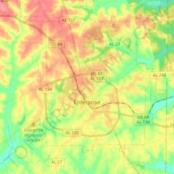
Name: Enterprise topographic map, elevation, terrain.
Location: Enterprise, Coffee County, Alabama, United States (31.26519 -85.88858 31.38606 -85.77779)
Average elevation: 100 m
Minimum elevation: 57 m
Maximum elevation: 146 m
Other topographic maps
Click on a map to view its topography, its elevation and its terrain.
New Brockton
United States > Alabama > Coffee County
New Brockton, Coffee County, Alabama, 36351, United States
Average elevation: 122 m
Damascus
United States > Alabama > Coffee County
Damascus, Coffee County, Alabama, United States
Average elevation: 102 m
College Heights
United States > Alabama > Coffee County > Enterprise
College Heights, Enterprise, Coffee County, Alabama, 36331, United States
Average elevation: 103 m
Indian Springs
United States > Alabama > Coffee County > Enterprise > Indian Springs
Indian Springs, Enterprise, Coffee County, Alabama, 36331, United States
Average elevation: 96 m
Kinston
United States > Alabama > Coffee County > Kinston
Kinston, Coffee County, Alabama, 36453, United States
Average elevation: 72 m
Valley Hills
United States > Alabama > Coffee County > Enterprise > Valley Hills
Valley Hills, Enterprise, Coffee County, Alabama, 36330, United States
Average elevation: 109 m
Elba
United States > Alabama > Coffee County > Elba
Elba, Coffee County, Alabama, 36323, United States
Average elevation: 80 m