
Thank you for supporting this site ❤️
Make a donation
Make a donation
Rubavu topographic map
Click on the map to display elevation.
Thank you for supporting this site ❤️
Make a donation
Make a donation
About this map
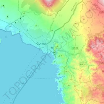
Name: Rubavu topographic map, elevation, terrain.
Location: Rubavu, Gisenyi, Rubavu, Western Province, Rwanda (-1.85355 29.09986 -1.53355 29.41986)
Average elevation: 1,799 m
Minimum elevation: 1,455 m
Maximum elevation: 3,044 m
Thank you for supporting this site ❤️
Make a donation
Make a donation
Other topographic maps
Click on a map to view its topography, its elevation and its terrain.