
Thank you for supporting this site ❤️
Make a donation
Make a donation
Valdez-Cordova (CA) topographic map
Click on the map to display elevation.
Thank you for supporting this site ❤️
Make a donation
Make a donation
About this map
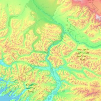
Name: Valdez-Cordova (CA) topographic map, elevation, terrain.
Location: Valdez-Cordova (CA), Alaska, United States (60.56209 -145.49145 61.96209 -144.09145)
Average elevation: 1,004 m
Minimum elevation: -2 m
Maximum elevation: 4,897 m
Thank you for supporting this site ❤️
Make a donation
Make a donation
Other topographic maps
Click on a map to view its topography, its elevation and its terrain.