
Thank you for supporting this site ❤️
Make a donation
Make a donation
Sokoto State topographic map
Click on the map to display elevation.
Thank you for supporting this site ❤️
Make a donation
Make a donation
About this map
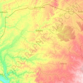
Name: Sokoto State topographic map, elevation, terrain.
Location: Sokoto State, Nigeria (11.53031 4.14076 13.88565 6.82012)
Average elevation: 307 m
Minimum elevation: 149 m
Maximum elevation: 644 m
Thank you for supporting this site ❤️
Make a donation
Make a donation
Other topographic maps
Click on a map to view its topography, its elevation and its terrain.