
Le Grand Carvidy topographic map
Interactive map
Click on the map to display elevation.
About this map
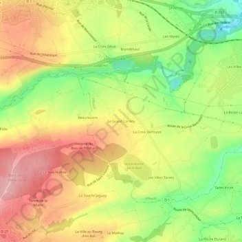
Name: Le Grand Carvidy topographic map, elevation, terrain.
Average elevation: 105 m
Minimum elevation: 26 m
Maximum elevation: 173 m
Other topographic maps
Click on a map to view its topography, its elevation and its terrain.
La Croix Bertrand
France > Bretagne > Côtes-d'Armor > Yffiniac
La Croix Bertrand, Yffiniac, Saint-Brieuc, Côtes-d'Armor, Bretagne, France métropolitaine, 22120, France
Average elevation: 99 m
Les Fraîches
France > Bretagne > Côtes-d'Armor > Yffiniac > Les Fraîches
Les Fraîches, Yffiniac, Saint-Brieuc, Côtes-d'Armor, Bretagne, France métropolitaine, 22120, France
Average elevation: 43 m