
Uckfield topographic map
Interactive map
Click on the map to display elevation.
About this map
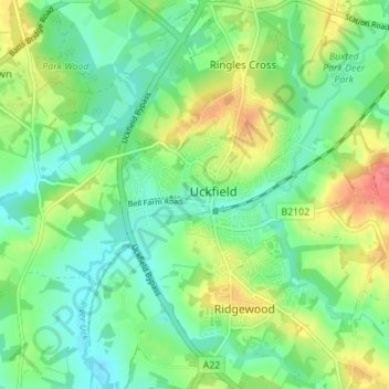
Name: Uckfield topographic map, elevation, terrain.
Location: Uckfield, Wealden, East Sussex, Engeland, Verenigd Koninkrijk (50.94883 0.07950 50.99231 0.12405)
Average elevation: 36 m
Minimum elevation: 11 m
Maximum elevation: 82 m
Other topographic maps
Click on a map to view its topography, its elevation and its terrain.
Forest Row
Verenigd Koninkrijk > Engeland > East Sussex > Wealden > Forest Row
Forest Row, Wealden, East Sussex, Engeland, Verenigd Koninkrijk
Average elevation: 104 m
Wych Cross
Verenigd Koninkrijk > Engeland > East Sussex > Wealden
Wych Cross, Forest Row, Wealden, East Sussex, Engeland, RH18 5JL, Verenigd Koninkrijk
Average elevation: 148 m