
Thank you for supporting this site ❤️
Make a donation
Make a donation
Friedrichshöhe topographic map
Click on the map to display elevation.
Thank you for supporting this site ❤️
Make a donation
Make a donation
Friedrichshöhe
Friedrichshöhe ist ein Ort im Stadtteil Sachsenbrunn der Stadt Eisfeld im Landkreis Hildburghausen in Thüringen.
Thank you for supporting this site ❤️
Make a donation
Make a donation
About this map
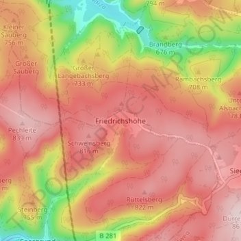
Name: Friedrichshöhe topographic map, elevation, terrain.
Average elevation: 739 m
Minimum elevation: 539 m
Maximum elevation: 856 m
Thank you for supporting this site ❤️
Make a donation
Make a donation
Other topographic maps
Click on a map to view its topography, its elevation and its terrain.
Harras
Deutschland > Thüringen > Landkreis Hildburghausen > Eisfeld
Bockstadt-Herbartswind (mit Bockstadt und Herbartswind) | Eisfeld | Harras | Heid | Hirschendorf | Sachsenbrunn (mit Friedrichshöhe, Saargrund, Schirnrod, Sophienau, Stelzen, Tossenthal und Weitesfeld) | Waffenrod/Hinterrod (mit Waffenrod und Hinterrod)
Average elevation: 448 m