
Thank you for supporting this site ❤️
Make a donation
Make a donation
Voiswinkel topographic map
Click on the map to display elevation.
Thank you for supporting this site ❤️
Make a donation
Make a donation
Voiswinkel
Voiswinkel (das „i“ ist ein Dehnungs-i, Aussprache daher Voohswinkel mit Betonung auf der zweiten Silbe) ist ein Ortsteil in Unterodenthal in der Gemeinde Odenthal im Rheinisch-Bergischen Kreis. Es liegt auf einer Anhöhe zwischen Bergisch Gladbach und Odenthal.
Thank you for supporting this site ❤️
Make a donation
Make a donation
About this map
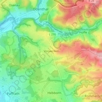
Name: Voiswinkel topographic map, elevation, terrain.
Average elevation: 131 m
Minimum elevation: 68 m
Maximum elevation: 222 m
Thank you for supporting this site ❤️
Make a donation
Make a donation
Other topographic maps
Click on a map to view its topography, its elevation and its terrain.
Scherfbachtal
Deutschland > Nordrhein-Westfalen > Rheinisch-Bergischer Kreis > Odenthal > Höffe
Average elevation: 165 m
Unterbreidbach
Deutschland > Nordrhein-Westfalen > Rheinisch-Bergischer Kreis > Odenthal > Neschen > Unterbreidbach
Average elevation: 198 m