
St. Leonhard am Wald topographic map
Interactive map
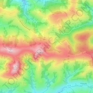
Click on the map to display elevation.
About this map
Name: St. Leonhard am Wald topographic map, elevation, terrain.
Average elevation: 601 m
Minimum elevation: 433 m
Maximum elevation: 781 m
Other topographic maps
Click on a map to view its topography, its elevation and its terrain.
Konradsheim
Österreich > Niederösterreich > Waidhofen an der Ybbs
Konradsheim, Waidhofen an der Ybbs, Niederösterreich, 3333, Österreich
Average elevation: 640 m
Gemeinde Waidhofen an der Ybbs
Österreich > Niederösterreich > Waidhofen an der Ybbs
Gemeinde Waidhofen an der Ybbs, Waidhofen an der Ybbs, Niederösterreich, 3340, Österreich
Average elevation: 568 m