
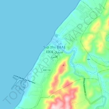
Sidi Ifni topographic map
Interactive map
Click on the map to display elevation.
About this map
Name: Sidi Ifni topographic map, elevation, terrain.
Average elevation: 69 m
Minimum elevation: 0 m
Maximum elevation: 405 m
Sidi Ifni liegt am Atlantischen Ozean etwa 170 km (Fahrtstrecke) südwestlich von Agadir in einer mittleren Höhe von ca. 30 m. Bis nach Marrakesch sind es etwa 400 km in nordöstlicher Richtung. Das Klima ist stark vom Atlantik und der Wüstenlandschaft des Hinterlandes geprägt; der eher spärliche Regen (ca. 135 mm/Jahr) fällt nahezu ausschließlich im Winterhalbjahr.