
Bo'stonliq Tumani topographic map
Interactive map
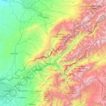
Click on the map to display elevation.
About this map
Name: Bo'stonliq Tumani topographic map, elevation, terrain.
Location: Bo'stonliq Tumani, Provinz Taschkent, Usbekistan (41.22391 69.58909 42.29508 71.26909)
Average elevation: 1,597 m
Minimum elevation: 303 m
Maximum elevation: 4,255 m
Other topographic maps
Click on a map to view its topography, its elevation and its terrain.
Olmaliq
Usbekistan > Provinz Taschkent > Piskent Tumani
Olmaliq, Piskent Tumani, Provinz Taschkent, Usbekistan
Average elevation: 571 m
Аксу
Usbekistan > Provinz Taschkent > Ohangaron Tumani
Аксу, Ohangaron Tumani, Provinz Taschkent, Usbekistan
Average elevation: 2,479 m
X лет Узб ССР
Usbekistan > Provinz Taschkent > Bo'ka Tumani
X лет Узб ССР, Bo'ka Tumani, Provinz Taschkent, Usbekistan
Average elevation: 309 m
Bekobod
Usbekistan > Provinz Taschkent > Bekobod
Bekobod, Provinz Taschkent, Usbekistan
Average elevation: 318 m
Bekobod
Usbekistan > Provinz Taschkent > Bekobod
Bekobod, Provinz Taschkent, Usbekistan
Average elevation: 317 m
Toshloq
Usbekistan > Provinz Taschkent > Quyichirchiq Tumani
Toshloq, Quyichirchiq Tumani, Provinz Taschkent, Usbekistan
Average elevation: 370 m
Syrdarja
Usbekistan > Provinz Taschkent > Yuqori Qo'shtamg'ali
Syrdarja, Yuqori Qo'shtamg'ali, Bekobod tumani, Provinz Taschkent, Usbekistan
Average elevation: 361 m
Qo'ng'irot
Usbekistan > Provinz Taschkent > Qo'ng'irot
Qo'ng'irot, Oqqorgon tumani, Provinz Taschkent, Usbekistan
Average elevation: 347 m
Beshtut
Usbekistan > Provinz Taschkent > Beshtut
Beshtut, Bo'stonlik Tumani, Provinz Taschkent, Usbekistan
Average elevation: 895 m
Aqmola
Usbekistan > Provinz Taschkent > Yuqorichirchiq Tumani
Aqmola, Yuqorichirchiq Tumani, Provinz Taschkent, Usbekistan
Average elevation: 456 m