
若尔盖县 topographic map
Interactive map
Click on the map to display elevation.
About this map
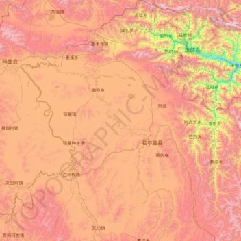
Name: 若尔盖县 topographic map, elevation, terrain.
Location: 若尔盖县, 阿坝藏族羌族自治州, Sichuan, Chine (33.01830 102.13560 34.31471 103.63682)
Average elevation: 3,513 m
Minimum elevation: 2,111 m
Maximum elevation: 4,742 m
Other topographic maps
Click on a map to view its topography, its elevation and its terrain.