
Thank you for supporting this site ❤️
Make a donation
Make a donation
El Refugio topographic map
Click on the map to display elevation.
Thank you for supporting this site ❤️
Make a donation
Make a donation
About this map
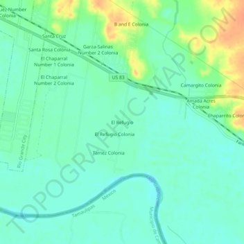
Name: El Refugio topographic map, elevation, terrain.
Location: El Refugio, Starr County, Texas, 78547, United States (26.32035 -98.77586 26.36035 -98.73586)
Average elevation: 50 m
Minimum elevation: 38 m
Maximum elevation: 77 m
Thank you for supporting this site ❤️
Make a donation
Make a donation