
Tondela topographic map
Interactive map
Click on the map to display elevation.
About this map
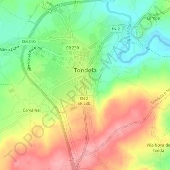
Name: Tondela topographic map, elevation, terrain.
Location: Tondela, Viseu, Viseu Dão-Lafões, Centro, Portugal (40.50046 -8.09388 40.52762 -8.06638)
Average elevation: 303 m
Minimum elevation: 246 m
Maximum elevation: 366 m
Other topographic maps
Click on a map to view its topography, its elevation and its terrain.
Malhapão de Cima
Portugal > Centro > Tondela > Malhapão de Cima
Malhapão de Cima, Mosteirinho, U.F S.João de Monte e Mosteirinho, Tondela, Viseu, Viseu Dão-Lafões, Centro, Portugal
Average elevation: 769 m
Casal de Cima
Portugal > Centro > Tondela > Casal de Cima
Casal de Cima, Vilar de Besteiros, U.F Vilar de Besteiros Monteiro de Fráguas, Tondela, Viseu, Viseu Dão-Lafões, Centro, Portugal
Average elevation: 342 m
Caparrosa
Portugal > Centro > U.F Caparrosa e Silvares > Tondela
Caparrosa, U.F Caparrosa e Silvares, Tondela, Viseu, Viseu Dão-Lafões, Centro, Portugal
Average elevation: 470 m