
Viseu topographic map
Interactive map
Click on the map to display elevation.
Viseu
The Municipality is characterized by an irregular surface with altitudes ranging between 400 and 700 metres (1,300 and 2,300 feet). With a rough terrain, it has numerous water courses. These are found in three basins: the Vouga, the Dão and the Paiva.
About this map
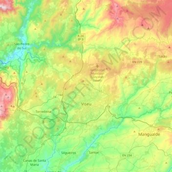
Name: Viseu topographic map, elevation, terrain.
Location: Viseu, Portugal (40.53573 -8.09159 40.84260 -7.75898)
Average elevation: 469 m
Minimum elevation: 146 m
Maximum elevation: 1,067 m