
Thank you for supporting this site ❤️
Make a donation
Make a donation
Mosel topographic map
Click on the map to display elevation.
Thank you for supporting this site ❤️
Make a donation
Make a donation
About this map
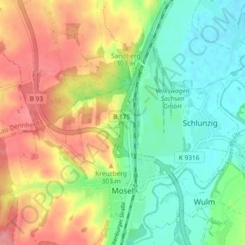
Name: Mosel topographic map, elevation, terrain.
Location: Mosel, Zwickau-Nord, Zwickau, Sachsen, Deutschland (50.77194 12.44663 50.81284 12.49635)
Average elevation: 278 m
Minimum elevation: 240 m
Maximum elevation: 329 m
Thank you for supporting this site ❤️
Make a donation
Make a donation
Other topographic maps
Click on a map to view its topography, its elevation and its terrain.
FFH Mittleres Zwickauer Muldetal (Teilfläche 2: Mulde südlich Glauchau)
Deutschland > Sachsen > Zwickau > Zwickau
Average elevation: 276 m