
Leper topographic map
Interactive map
Click on the map to display elevation.
About this map
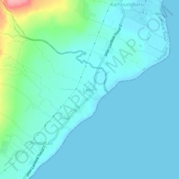
Name: Leper topographic map, elevation, terrain.
Location: Leper, Lombok Timur, West-Nusa Tenggara, Indonesië (-8.47052 116.67335 -8.43052 116.71335)
Average elevation: 18 m
Minimum elevation: 0 m
Maximum elevation: 121 m
Other topographic maps
Click on a map to view its topography, its elevation and its terrain.
Lombok Utara
Indonesië > West-Nusa Tenggara
Lombok Utara, West-Nusa Tenggara, Nusa Tenggara, Indonesië
Average elevation: 240 m
Gili Air
Indonesië > West-Nusa Tenggara > Lombok Utara
Gili Air, Lombok Utara, West-Nusa Tenggara, 83300, Indonesië
Average elevation: 1 m
Tambora
Indonesië > West-Nusa Tenggara
Tambora, Bima, West-Nusa Tenggara, Indonesië
Average elevation: 1,393 m