
Make a donation
Rangpur Division topographic map
Click on the map to display elevation.
Make a donation
About this map
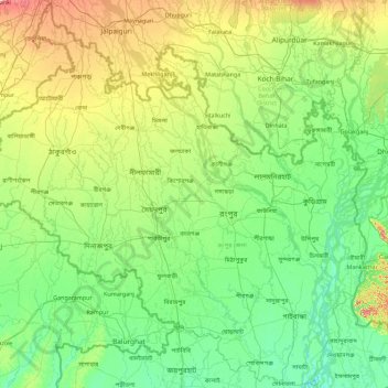
Name: Rangpur Division topographic map, elevation, terrain.
Location: Rangpur Division, Bangladesh (25.03653 88.08551 26.63589 89.88728)
Average elevation: 42 m
Minimum elevation: 10 m
Maximum elevation: 169 m
Make a donation
Other topographic maps
Click on a map to view its topography, its elevation and its terrain.
Dhaka
Bangladesh > Dhaka Division > Dhaka Metropolitan
In 2013, suburban services to Narayanganj and Gazipur cities were upgraded using diesel electric multiple unit trains. The Dhaka Metro Rail feasibility study has been completed. A 20.1-kilometre (12.5 mi), $2.8-billion Phase 1 metro route is being negotiated by the Government with Japan International…
Average elevation: 7 m
Chattogram
Bangladesh > Chattogram Division > Chattogram
Chittagong lies at 22°22′0″N 91°48′0″E / 22.36667°N 91.80000°E / 22.36667; 91.80000. It straddles the coastal foothills of the Chittagong Hill Tracts in southeastern Bangladesh. The Karnaphuli River runs along the southern banks of the city, including its central business district. The…
Average elevation: 6 m
Rangamati
Bangladesh > Chattogram Division > Rangamati Sadar Upazila
Rangamati (Bengali: রাঙামাটি) is a town and the administrative headquarters of Rangamati District in the Chittagong Hill Tracts of Bangladesh. The town is located at 22°37'60N 92°12'0E and has an elevation of 14 metres (46 ft) above sea level.
Average elevation: 68 m
Make a donation
Make a donation
Make a donation
Make a donation
BINA pond
Bangladesh > Mymensingh Division > Mymensingh Sadar Upazila > Mymensingh
Average elevation: 15 m
Make a donation
Make a donation
Make a donation
Sajek
Bangladesh > Chattogram Division > Bagaichhari Upazila
Sajek Valley (Bengali: সাজেক উপত্যকা) is a popular tourist spot in Bangladesh, situated among the hills of the Kasalong range of mountains in the northern area of the Chittagong Hill Tracts. Referred to as the "Queen of Hills" and the "Roof of Rangamati", the valley is known for its…
Average elevation: 209 m
Make a donation
Make a donation
Cox's Bazar
Bangladesh > Chattogram Division
Cox's Bazar lies on a coastal plain in the southeastern corner of Bangladesh. From above, the plain appears to bulge out into the Bay of Bengal. Along the shore is an extensive area of beach and dunes. Most of the city is built on a floodplain that is lower in elevation than the dunes, making it more…
Average elevation: 8 m
Make a donation
Takerghat Mine Lake
Bangladesh > Sylhet Division > Tahirpur Upazila > Eiman Pur Para
Average elevation: 70 m
Make a donation
Chattogram
Bangladesh > Chattogram Division > Chittagong City
Chittagong lies at 22°20′06″N 91°49′57″E / 22.33500°N 91.83250°E / 22.33500; 91.83250. It straddles the coastal foothills of the Chittagong Hill Tracts in south-eastern Bangladesh. The Karnaphuli River runs along the southern banks of the city, including its central business district. The…
Average elevation: 6 m
Make a donation
Chandgaon Residential Area
Bangladesh > Chattogram Division > Chittagong City > Chattogram
Average elevation: 5 m
Shapla Chattar
Bangladesh > Rangpur Division > Kurigram Sadar Upazila > Kurigram
Average elevation: 29 m
Make a donation
Make a donation
Buriganga River
Bangladesh > Dhaka Division > Keraniganj Subdistrict > Keraniganj
Average elevation: 8 m
Make a donation
Make a donation
Fatikchhari, Chittagong, Bangladesh
Bangladesh > Chittagong Division > Fatikchhari Upazila > Fatikchhari
Average elevation: 11 m
Make a donation
Make a donation
Sylhet
Bangladesh > Sylhet Division > Sylhet Sadar Upazila
Sylhet is located in the northeastern region of Bangladesh within the Sylhet Division, the Sylhet District, and Sylhet Sadar Upazila. Sylhet has a typical Bangladeshi tropical monsoon climate (Köppen Am) bordering on a humid subtropical climate (Cwa) at higher elevations. The rainy season runs from April to…
Average elevation: 14 m
Make a donation
Chattogram
Bangladesh > Chittagong Division
Chittagong lies at 22°20′06″N 91°49′57″E / 22.33500°N 91.83250°E / 22.33500; 91.83250. It straddles the coastal foothills of the Chittagong Hill Tracts in south-eastern Bangladesh. The Karnaphuli River runs along the southern banks of the city, including its central business district. The…
Average elevation: 6 m
Make a donation
Make a donation
Make a donation
Make a donation
Make a donation
Make a donation