
Thank you for supporting this site ❤️
Make a donation
Make a donation
Carrollton topographic map
Click on the map to display elevation.
Thank you for supporting this site ❤️
Make a donation
Make a donation
About this map
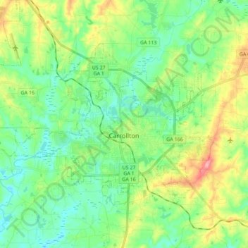
Name: Carrollton topographic map, elevation, terrain.
Location: Carrollton, Carroll County, Georgia, United States (33.53979 -85.18621 33.63339 -85.01439)
Average elevation: 329 m
Minimum elevation: 287 m
Maximum elevation: 424 m
Thank you for supporting this site ❤️
Make a donation
Make a donation
Other topographic maps
Click on a map to view its topography, its elevation and its terrain.