Geolocate

Finland topographic map

Click on the map to display elevation.

About this map

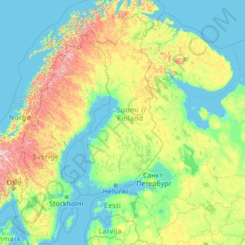
Name: Finland topographic map, elevation, terrain.

Location: Finland (55.74678 18.42092 70.74678 33.42092)

Average elevation: 163 m

Minimum elevation: -3 m

Maximum elevation: 1,816 m

Other topographic maps

Click on a map to view its topography, its elevation and its terrain.

Vääräjärvi

Finland > Uusimaa > Espoo

Average elevation: 76 m

Vääräjärvi

Finland > Pirkanmaa > Kuhmoinen

Average elevation: 151 m

Vihti

Finland > Uusimaa

Average elevation: 77 m

Helsinki

Finland > Uusimaa

Average elevation: 8 m

Turku

Finland > Southwest Finland

Operational since 1955, the city's weather station is located at an altitude of 47 metres (154 feet) at Turku Airport. The weather in the city itself is affected by the proximity of the sea, so the wintertime temperatures are often milder than those measured at the airport. The moderating impact of the sea…

Average elevation: 32 m

Helsinki

Finland > Uusimaa

Average elevation: 8 m

Pääskyvuori

Finland > Southwest Finland > Turku

Average elevation: 33 m

Pojo

Finland > Uusimaa > Raseborg

Average elevation: 35 m

Vantaa

Finland > Uusimaa

Average elevation: 36 m

Lapland

Finland

Lapland is the largest and northernmost region of Finland. The 21 municipalities in the region cooperate in a Regional Council. Lapland borders the Finnish region of North Ostrobothnia in the south. It also borders the Gulf of Bothnia and the Norrbotten County in Sweden, Finnmark County and the Troms County in…

Average elevation: 249 m

Vaasa

Finland > Ostrobothnia

Average elevation: 11 m

Lapland

Finland

Lapland is the largest and northernmost region of Finland. The 21 municipalities in the region cooperate in a Regional Council. Lapland borders the Finnish region of North Ostrobothnia in the south. It also borders the Gulf of Bothnia and the Norrbotten County in Sweden, Finnmark County and the Troms County in…

Average elevation: 249 m

Tampere

Finland > Pirkanmaa

Average elevation: 121 m

Märket

Finland > Åland Islands > Åland Islands > Hammarland

The island consists of mostly smooth diabase rock, with a maximum natural elevation of 2 m (6.6 ft). Most of the area is regularly washed over with seawater in storms, and scoured by drift ice in winter. Plant life, which is limited to low-growing grasses and herbs, persists only in some protected spots.…

Average elevation: 0 m

Porvoo

Finland > Uusimaa

Average elevation: 13 m

Inari

Finland > Lapland

Average elevation: 256 m

Kartano

Finland > Satakunta > Pori > Noormarkku

Average elevation: 35 m

Helsinki

Finland > Uusimaa

Average elevation: 8 m

Hamina

Finland > Kymenlaakso

Average elevation: 20 m

Suomenlinna

Finland > Uusimaa > Helsinki

Average elevation: 2 m

Helvetinjärvi

Finland > Pirkanmaa > Lempäälä

Average elevation: 133 m

Pori

Finland > Satakunta

Average elevation: 36 m

Helsinki

Finland > Uusimaa

Average elevation: 8 m

Akaa

Finland > Pirkanmaa

Average elevation: 101 m

Koski Tl

Finland > Southwest Finland

Average elevation: 91 m

Pori

Finland > Satakunta

Average elevation: 36 m

Harjavalta

Finland > Satakunta

Average elevation: 36 m

Espoo

Finland > Uusimaa

The minerals and structures of the rocky and hilly topography of Espoo were formed about 1880 to 1650 million years ago. Particularly the Weichselian glaciation has had an effect on the current environment - the continental ice sheet withdrew from what is now Espoo about 13 thousand years ago. The first areas…

Average elevation: 22 m

Nykarleby

Finland > Ostrobothnia

Average elevation: 16 m

Nuuksio national park

Finland > Uusimaa > Vihti

Average elevation: 67 m

Mikkeli

Finland > South Savo

Average elevation: 104 m

Jyväskylä

Finland > Central Finland

Average elevation: 130 m

Lemmenjoki National Park

Finland > Lapland

Average elevation: 325 m

Koli National Park

Finland > North Karelia > Lieksa

Average elevation: 134 m

Velskola

Finland > Uusimaa > Espoo

Average elevation: 80 m

Masku

Finland > Southwest Finland

Average elevation: 32 m

Urho Kekkonen National Park

Finland > Lapland

Average elevation: 271 m

Salo

Finland > Southwest Finland

Average elevation: 50 m

Lohjansaari

Finland > Uusimaa > Lohja

Average elevation: 44 m

VI

Finland > Southwest Finland > Turku

Average elevation: 19 m

Käsivarsi Wilderness Area

Finland > Lapland

Average elevation: 629 m

Turku

Finland > Southwest Finland

Operational since 1955, the city's weather station is located at an altitude of 47 metres (154 feet) at Turku Airport. The weather in the city itself is affected by the proximity of the sea, so the wintertime temperatures are often milder than those measured at the airport. The moderating impact of the sea…

Average elevation: 32 m

Hämeenlinna

Finland > Kanta-Häme

Average elevation: 111 m

Naantali

Finland > Southwest Finland

Average elevation: 11 m

Pukkila

Finland > Uusimaa

Average elevation: 64 m

Kymi

Finland

Average elevation: 68 m

Paimio

Finland > Southwest Finland

Average elevation: 43 m

Seinäjoki

Finland > South Ostrobothnia

Average elevation: 91 m

Mäntyharju

Finland > South Savo

Average elevation: 101 m

Joensuu

Finland > North Karelia

Average elevation: 113 m

Kunnarla

Finland > Uusimaa > Espoo

Average elevation: 45 m

Kajaani

Finland > Kainuu

Average elevation: 169 m

Pyöli

Finland > Southwest Finland > Salo > Muurla

Average elevation: 44 m

Turku

Finland > Southwest Finland

Operational since 1955, the city's weather station is located at an altitude of 47 metres (154 feet) at Turku Airport. The weather in the city itself is affected by the proximity of the sea, so the wintertime temperatures are often milder than those measured at the airport. The moderating impact of the sea…

Average elevation: 32 m

Penni

Finland > Pirkanmaa > Ikaalinen

Average elevation: 80 m

Jyväskylä

Finland > Central Finland

Average elevation: 130 m

Turku

Finland > Southwest Finland

Operational since 1955, the city's weather station is located at an altitude of 47 metres (154 feet) at Turku Airport. The weather in the city itself is affected by the proximity of the sea, so the wintertime temperatures are often milder than those measured at the airport. The moderating impact of the sea…

Average elevation: 32 m

Vaasa

Finland > Ostrobothnia

Average elevation: 11 m

Imatra

Finland > South Karelia

Average elevation: 75 m

Iso-Melkutin

Finland > Kanta-Häme > Loppi

Average elevation: 125 m

Förby

Finland > Southwest Finland > Salo

Average elevation: 8 m

Syöte national park

Finland > North Ostrobothnia

Syöte National Park (Syötteen kansallispuisto) is a national park in the area of Pudasjärvi, Posio and Taivalkoski municipalities, in Northern Ostrobothnia and Lapland regions of Finland. Syöte National Park is a chain of old-growth forests, part of which is high altitude forest. One fourth of the area of…

Average elevation: 262 m

Äänekoski

Finland > Central Finland

Average elevation: 135 m

Kauniainen

Finland > Uusimaa

Average elevation: 34 m

Muuratsalo

Finland > Central Finland > Jyväskylä

Average elevation: 94 m

Nokia

Finland > Pirkanmaa

Average elevation: 107 m

Räntämäki

Finland > Southwest Finland > Turku

Average elevation: 21 m

Eura

Finland > Satakunta

Average elevation: 48 m

Haarla

Finland > Southwest Finland > Turku

Average elevation: 7 m

Ivalo

Finland > Lapland

Average elevation: 125 m

Kimitoön

Finland > Southwest Finland

Average elevation: 8 m

Kotka

Finland > Kymenlaakso

Average elevation: 9 m

Kotka

Finland > Kymenlaakso

Average elevation: 9 m

Oulu

Finland > North Ostrobothnia

Average elevation: 46 m

Pasila

Finland > Uusimaa > Helsinki

Average elevation: 23 m

Jerisjärvi

Finland > Lapland > Kittilä

Average elevation: 295 m

Oulu

Finland > North Ostrobothnia

Average elevation: 45 m

Ylikiiminki

Finland > North Ostrobothnia > Oulu

Average elevation: 73 m

Artukainen

Finland > Southwest Finland > Turku

Average elevation: 12 m

Asikkala

Finland > Päijät-Häme

Average elevation: 105 m

Raahe

Finland > North Ostrobothnia

Average elevation: 30 m

Jäkärlä

Finland > Southwest Finland > Turku

Average elevation: 39 m

Rautalampi

Finland > North Savo

Average elevation: 118 m

Veikkola

Finland > Uusimaa > Kirkkonummi

Average elevation: 63 m

Linjat

Finland > Uusimaa > Helsinki

Average elevation: 16 m

Degerby

Finland > Uusimaa > Ingå

Average elevation: 8 m

Iisalmi

Finland > North Savo

Average elevation: 121 m

Vihtakoski

Finland > North Savo > Kaavi

Average elevation: 111 m

Höga Lövö

Finland > Uusimaa > Kirkkonummi

Average elevation: 1 m

Kittilä

Finland > Lapland

Kittilä has a subarctic climate (Dfc) as a result of its northerly location and being far inland, which renders strong seasonal shifts. The sun does not set between 30 May and 15 July (47 days), and white nights lasts from early May to early August. The period that the sun does not rise lasts from 14 December…

Average elevation: 254 m

Lappeenranta

Finland > South Karelia

Average elevation: 63 m

Ruovesi

Finland > Pirkanmaa

Average elevation: 132 m

Oulu

Finland > North Ostrobothnia

Average elevation: 46 m

Kaarela

Finland > Uusimaa > Helsinki

Average elevation: 29 m

Kontiolahti

Finland > North Karelia

Average elevation: 115 m

Karina

Finland > Päijät-Häme > Asikkala

Average elevation: 108 m

Rovaniemi

Finland > Lapland

Average elevation: 167 m