
Make a donation
Punta Bandera topographic map
Click on the map to display elevation.
Make a donation
About this map
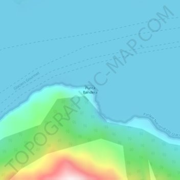
Name: Punta Bandera topographic map, elevation, terrain.
Average elevation: 258 m
Minimum elevation: 174 m
Maximum elevation: 781 m
Make a donation
Other topographic maps
Click on a map to view its topography, its elevation and its terrain.
Municipio de El Calafate
Argentinien > Provinz Santa Cruz
El Calafate ist Hauptstadt des Departamento Lago Argentino und Zentrum des Tourismus für den Nationalpark Los Glaciares mit dem bekannten Gletscher Perito Moreno am Fuß der Anden. Es ist eine rasch wachsende Kleinstadt im Südwesten Argentiniens in der Provinz Santa Cruz am Ufer des Lago Argentino auf etwa…
Average elevation: 432 m
Make a donation
Make a donation
El Calafate
Argentinien > Provinz Santa Cruz
El Calafate ist Hauptstadt des Departamento Lago Argentino und Zentrum des Tourismus für den Nationalpark Los Glaciares mit dem bekannten Gletscher Perito Moreno am Fuß der Anden. Es ist eine rasch wachsende Kleinstadt im Südwesten Argentiniens in der Provinz Santa Cruz am Ufer des Lago Argentino auf etwa…
Average elevation: 250 m
Make a donation