
Thank you for supporting this site ❤️
Make a donation
Make a donation
Ilay topographic map
Click on the map to display elevation.
Thank you for supporting this site ❤️
Make a donation
Make a donation
About this map
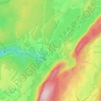
Name: Ilay topographic map, elevation, terrain.
Average elevation: 824 m
Minimum elevation: 639 m
Maximum elevation: 1,035 m
Thank you for supporting this site ❤️
Make a donation
Make a donation
Other topographic maps
Click on a map to view its topography, its elevation and its terrain.
Lac d'Ilay
France > Bourgogne-Franche-Comté > Jura > La Chaux-du-Dombief > Ilay
De forme très allongée orientée SW-NE, le lac d'Ilay mesure 1,9 km de long et 0,4 km de large avec une superficie de 72 hectares et une profondeur moyenne de 10 m (double cuvette avec une profondeur maximale de 32 m) et il se situe à 774 mètres d'altitude. Son bassin versant est limité à 5,5 km². Il…
Average elevation: 808 m