
Thank you for supporting this site ❤️
Make a donation
Make a donation
Thoirette topographic map
Click on the map to display elevation.
Thank you for supporting this site ❤️
Make a donation
Make a donation
About this map
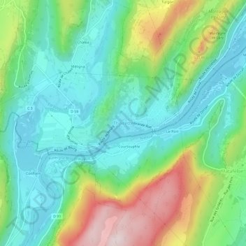
Name: Thoirette topographic map, elevation, terrain.
Average elevation: 427 m
Minimum elevation: 273 m
Maximum elevation: 776 m
Thank you for supporting this site ❤️
Make a donation
Make a donation
Other topographic maps
Click on a map to view its topography, its elevation and its terrain.
Barrage de Coiselet
France > Bourgogne-Franche-Comté > Jura > Thoirette-Coisia > Le Montain
Average elevation: 442 m
Thank you for supporting this site ❤️
Make a donation
Make a donation