
Thank you for supporting this site ❤️
Make a donation
Make a donation
Mountain Island Lake topographic map
Click on the map to display elevation.
Thank you for supporting this site ❤️
Make a donation
Make a donation
Mountain Island Lake
Mountain Island Lake is a lake northwest of Charlotte, North Carolina created in 1924 to coincide with the building of Mountain Island Hydroelectric Station. It is named after the mountain which appears as an island in the lake, and the surrounding area is identified by the lake's name. The shape of the lake follows the meander of the Catawba River's course, dammed near the Mount Holly Wastewater Plant. Full pond elevation is approximately 647.5 feet (197 m). The lake has around 3,281 acres (13 km2) of surface area and 61 miles (98 km) of shoreline.
Thank you for supporting this site ❤️
Make a donation
Make a donation
About this map
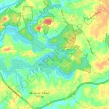
Name: Mountain Island Lake topographic map, elevation, terrain.
Average elevation: 216 m
Minimum elevation: 195 m
Maximum elevation: 248 m
Thank you for supporting this site ❤️
Make a donation
Make a donation