
Make a donation
Antofalla topographic map
Click on the map to display elevation.
Make a donation
About this map
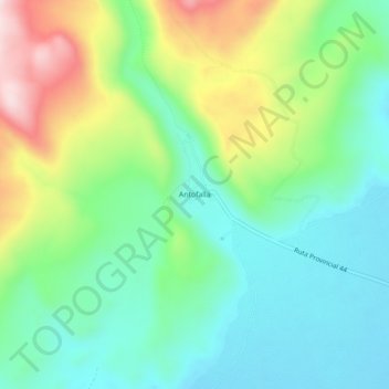
Name: Antofalla topographic map, elevation, terrain.
Average elevation: 3,482 m
Minimum elevation: 3,344 m
Maximum elevation: 3,775 m
Make a donation
Other topographic maps
Click on a map to view its topography, its elevation and its terrain.
Salinas Grandes
The Salinas Grandes ('Salina' is a spanish word for salt flat) is a large salt flat in central-northern Argentina, spanning the borders of four provinces (Córdoba, Catamarca, La Rioja and Santiago del Estero), at an average altitude of 180 metres (590 ft) above sea level, and having an area of about 4,700 km2.
Average elevation: 303 m
Make a donation
Salar del Hombre Muerto
Salar del Hombre Muerto lies at 4,300–4,100 metres (14,100–13,500 ft) elevation in the southern Puna and is surrounded by mountains, including volcanoes and summits reaching elevations that exceed 5,000 metres (16,000 ft). The Galán volcano lies just south of Hombre Muerto and has produced large…
Average elevation: 4,089 m
Make a donation
Make a donation
Salinas Grandes
The Salinas Grandes ('Salina' is a spanish word for salt flat) is a large salt flat in central-northern Argentina, spanning the borders of four provinces (Córdoba, Catamarca, La Rioja and Santiago del Estero), at an average altitude of 180 metres (590 ft) above sea level, and having an area of about 4,700 km2.
Average elevation: 303 m
Make a donation
Antofagasta de la Sierra
Antofagasta de la Sierra is a high altitude settlement, the majority of its inhabitants are descended from the Diaguitas and Atacameños.
Average elevation: 3,382 m