
Thank you for supporting this site ❤️
Make a donation
Make a donation
Koungou topographic map
Click on the map to display elevation.
Thank you for supporting this site ❤️
Make a donation
Make a donation
About this map
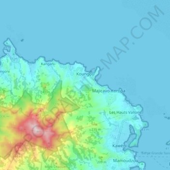
Name: Koungou topographic map, elevation, terrain.
Location: Koungou, Mayotte, 97600, France (-12.76589 45.14637 -12.71749 45.23614)
Average elevation: 79 m
Minimum elevation: -4 m
Maximum elevation: 550 m
Thank you for supporting this site ❤️
Make a donation
Make a donation
Other topographic maps
Click on a map to view its topography, its elevation and its terrain.