
Heinratsberg topographic map
Interactive map
Click on the map to display elevation.
About this map
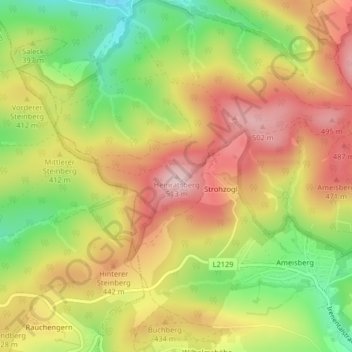
Name: Heinratsberg topographic map, elevation, terrain.
Average elevation: 398 m
Minimum elevation: 266 m
Maximum elevation: 512 m
Other topographic maps
Click on a map to view its topography, its elevation and its terrain.
Brettwies
Österreich > Niederösterreich > Bezirk St. Pölten > Gemeinde Tullnerbach > Irenental
Brettwies, Irenental, Gemeinde Tullnerbach, Bezirk St. Pölten, Niederösterreich, 3013, Österreich
Average elevation: 381 m