
Idaho topographic map
Interactive map
Click on the map to display elevation.
About this map
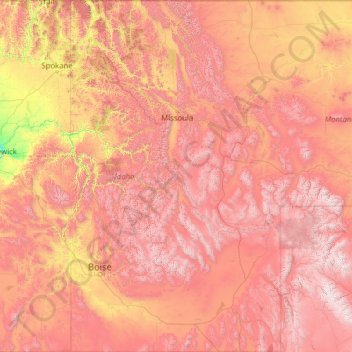
Name: Idaho topographic map, elevation, terrain.
Location: Idaho, United States (41.98883 -117.24303 49.00084 -111.04356)
Average elevation: 1,533 m
Minimum elevation: 102 m
Maximum elevation: 4,034 m
Idaho's climate varies widely. Although the state's western border is about 330 miles (530 km) from the Pacific Ocean, the maritime influence is still felt in Idaho; especially, in the winter when cloud cover, humidity, and precipitation are at their maximum extent. This influence has a moderating effect in the winter where temperatures are not as low as would otherwise be expected for a northern state with predominantly high elevations. In the panhandle, moist air masses from the coast are released as precipitation over the North Central Rockies forests, creating the North American inland temperate rainforest. The maritime influence is least prominent in the state's eastern part where the precipitation patterns are often reversed, with wetter summers and drier winters, and seasonal temperature differences are more extreme, showing a more semi-arid continental climate.
Other topographic maps
Click on a map to view its topography, its elevation and its terrain.
Sacramento
United States > California > Sacramento County
Sacramento, Sacramento County, California, United States
Average elevation: 10 m
Houston
United States > Texas > Harris County
Houston, Harris County, Texas, United States
Average elevation: 25 m
New Orleans
United States > Louisiana > Orleans Parish
New Orleans, Orleans Parish, Louisiana, United States
Average elevation: 1 m
Central Park
United States > New York > New York County > New York
Central Park, New York County, New York, United States
Average elevation: 26 m
Boulder
United States > Colorado > Boulder County
Boulder, Boulder County, Colorado, United States
Average elevation: 1,785 m
Madison
United States > Wisconsin > Dane County
Madison, Dane County, Wisconsin, United States
Average elevation: 284 m
Norfolk
United States > Virginia > Norfolk
Norfolk, Virginia, 23510, United States
Average elevation: 4 m
Indianapolis
United States > Indiana > Indianapolis
Indianapolis, Marion County, Indiana, 46204, United States
Average elevation: 241 m
Highlands Ranch
United States > Colorado > Douglas County
Highlands Ranch, Douglas County, Colorado, 80126, United States
Average elevation: 1,758 m
Mojave Desert
United States > California > San Bernardino County
Mojave Desert, San Bernardino County, CAL Fire Southern Region, California, United States
Average elevation: 1,228 m
Fort Lauderdale
United States > Florida > Broward County
Fort Lauderdale, Broward County, Florida, United States
Average elevation: 5 m
Blue Ridge Parkway
United States > North Carolina > Watauga County
Blue Ridge Parkway, Watauga County, North Carolina, United States
Average elevation: 505 m
Ruidoso
United States > New Mexico > Lincoln County
Ruidoso, Lincoln County, New Mexico, United States
Average elevation: 2,287 m
Brooklyn
United States > New York > New York
Brooklyn, Kings County, New York, United States
Average elevation: 9 m
Kitsap County
Kitsap County, Washington, United States
Average elevation: 138 m
Hillsborough County
Hillsborough County, Florida, United States
Average elevation: 20 m
Fresno
United States > California > Fresno County
Fresno, Fresno County, California, United States
Average elevation: 98 m