
Thank you for supporting this site ❤️
Make a donation
Make a donation
Nakorokula topographic map
Click on the map to display elevation.
Thank you for supporting this site ❤️
Make a donation
Make a donation
About this map
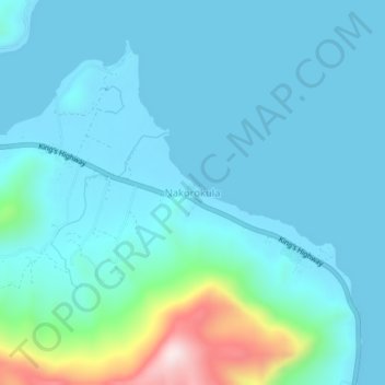
Name: Nakorokula topographic map, elevation, terrain.
Location: Nakorokula, Ra, Western, Fiji (-17.37292 178.20909 -17.33292 178.24909)
Average elevation: 72 m
Minimum elevation: 0 m
Maximum elevation: 516 m
Thank you for supporting this site ❤️
Make a donation
Make a donation