
Thank you for supporting this site ❤️
Make a donation
Make a donation
Pitseng topographic map
Click on the map to display elevation.
Thank you for supporting this site ❤️
Make a donation
Make a donation
About this map
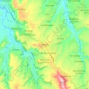
Name: Pitseng topographic map, elevation, terrain.
Location: Pitseng, Leribe District, Lesotho (-29.04053 28.16915 -28.96053 28.24915)
Average elevation: 1,784 m
Minimum elevation: 1,596 m
Maximum elevation: 2,132 m
Thank you for supporting this site ❤️
Make a donation
Make a donation
Other topographic maps
Click on a map to view its topography, its elevation and its terrain.