
Thank you for supporting this site ❤️
Make a donation
Make a donation
La Salle topographic map
Click on the map to display elevation.
Thank you for supporting this site ❤️
Make a donation
Make a donation
About this map
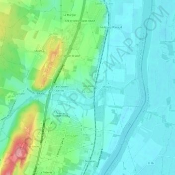
Name: La Salle topographic map, elevation, terrain.
Average elevation: 193 m
Minimum elevation: 165 m
Maximum elevation: 283 m
Thank you for supporting this site ❤️
Make a donation
Make a donation
Other topographic maps
Click on a map to view its topography, its elevation and its terrain.
La Queue du Renard
Frankreich > Burgund und Freigrafschaft > Saône-et-Loire > Dyo
Average elevation: 396 m