
Thank you for supporting this site ❤️
Make a donation
Make a donation
Uruapan topographic map
Click on the map to display elevation.
Thank you for supporting this site ❤️
Make a donation
Make a donation
About this map
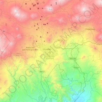
Name: Uruapan topographic map, elevation, terrain.
Location: Uruapan, Michoacán, Mexico (19.18496 -102.39363 19.62749 -101.93616)
Average elevation: 1,786 m
Minimum elevation: 459 m
Maximum elevation: 3,340 m
Thank you for supporting this site ❤️
Make a donation
Make a donation
Other topographic maps
Click on a map to view its topography, its elevation and its terrain.
Thank you for supporting this site ❤️
Make a donation
Make a donation
Ihuatzio
Mexico > Michoacán > Tzintzuntzan
Ihuatzio is located on the southeast of the Lake Pátzcuaro, about 8 kilometers southwest of the town center of Tzintzuntzan. Its average elevation is 2,052 meters above the sea level.
Average elevation: 2,052 m
Thank you for supporting this site ❤️
Make a donation
Make a donation