
Make a donation
Vyas (Damauli) topographic map
Click on the map to display elevation.
Make a donation
About this map
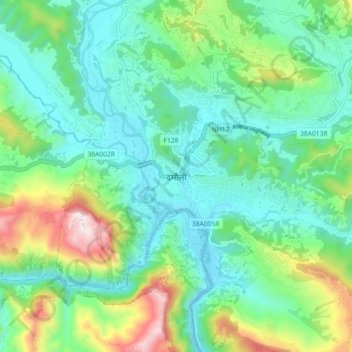
Name: Vyas (Damauli) topographic map, elevation, terrain.
Location: Vyas (Damauli), Byas, Tanahun, Gandaki Province, Nepal (27.93671 84.22935 28.01671 84.30935)
Average elevation: 502 m
Minimum elevation: 294 m
Maximum elevation: 1,079 m
Make a donation
Other topographic maps
Click on a map to view its topography, its elevation and its terrain.
Bandipur
Nepal > Gandaki Province > Tanahun
Bandipur is located at 27.56 N, 84.25 E and an elevation of 1030m on a mountain saddle (Mahabharat range) approximately 700m above the Marsyangdi River Valley, 143 km to the west of Kathmandu and 80 km to the east of Pokhara. Since 1998 it is connected by an 8 km access road from Dumre (Prithvi Highway). Until…
Average elevation: 719 m
Make a donation