
Meriden topographic map
Click on the map to display elevation.
About this map
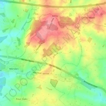
Name: Meriden topographic map, elevation, terrain.
Average elevation: 120 m
Minimum elevation: 78 m
Maximum elevation: 188 m
Other topographic maps
Click on a map to view its topography, its elevation and its terrain.
Knowle Locks
United Kingdom > England > Metropolitan Borough of Solihull > Knowle > Chadwick End
Average elevation: 113 m
Little Clowes Wood
United Kingdom > England > Metropolitan Borough of Solihull > Tidbury Green
Average elevation: 150 m
Waring's Green
United Kingdom > England > Metropolitan Borough of Solihull > Cheswick Green > Illshaw Heath
Average elevation: 139 m