
Make a donation
Gozo topographic map
Click on the map to display elevation.
Make a donation
Gozo
The University of Malta carried out geological and geophysical investigations in connection with a proposed sub-sea tunnel between Malta and Gozo following an agreement with Transport Malta. Scientific investigations included both desktop and field studies, passive seismic measurements, bathymetric mapping, and a seismic study. The University of Malta conducted a marine baseline study which incorporated a geological model of topography, stratigraphy, structure, geological, geophysical and tectonic properties of the study area. During this phase of the study, scientists deployed a 300-metre-long cable with a series of specialised receptors. An ‘air gun’ released bursts of compressed air every few metres. The compressed air was reflected to the receptors. Different geological layers reflect different frequencies. Scientists could thus determine the geological formations that lie beneath the surface and determine possible cracks. Following such tests, more tests will be carried out; these will consist in the drilling of a series of boreholes, up to 200 metres below the sea bed, to determine the rock strata below the surface.
Make a donation
About this map
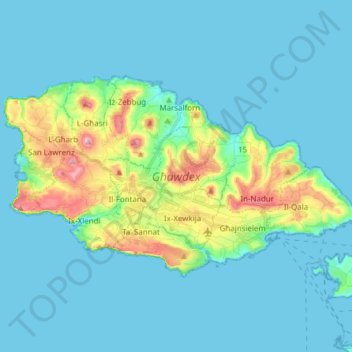
Name: Gozo topographic map, elevation, terrain.
Location: Gozo, Malta (36.01143 14.18347 36.08215 14.33643)
Average elevation: 31 m
Minimum elevation: 0 m
Maximum elevation: 189 m
Make a donation
Other topographic maps
Click on a map to view its topography, its elevation and its terrain.
Make a donation
Baħrija
Baħrija is one of the highest places in Malta, therefore the weather here is cooler than at lower elevations (it is also exposed to the cold northern winds coming over the sea). Most of the north of Malta is visible from this village, but the south west of Gozo (including Xlendi) is also visible, and on clear…
Average elevation: 116 m
Make a donation
Make a donation