
Thank you for supporting this site ❤️
Make a donation
Make a donation
Tozal del Fraile topographic map
Click on the map to display elevation.
Thank you for supporting this site ❤️
Make a donation
Make a donation
About this map
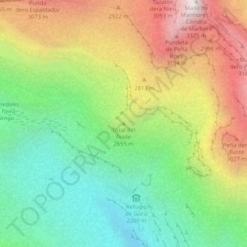
Name: Tozal del Fraile topographic map, elevation, terrain.
Location: Tozal del Fraile, Sobrarbe, Huesca, Aragón, España (42.67141 0.01300 42.67151 0.01310)
Average elevation: 2,566 m
Minimum elevation: 2,033 m
Maximum elevation: 3,307 m
Thank you for supporting this site ❤️
Make a donation
Make a donation
Other topographic maps
Click on a map to view its topography, its elevation and its terrain.
Thank you for supporting this site ❤️
Make a donation
Make a donation