
Make a donation
Malin topographic map
Click on the map to display elevation.
Make a donation
About this map
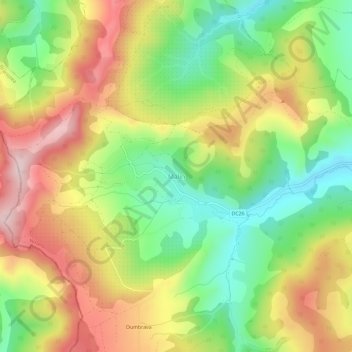
Name: Malin topographic map, elevation, terrain.
Location: Malin, Nușeni, Bistrița-Năsăud, 427204, Romania (47.09895 24.11723 47.13895 24.15723)
Average elevation: 440 m
Minimum elevation: 290 m
Maximum elevation: 610 m
Make a donation
Other topographic maps
Click on a map to view its topography, its elevation and its terrain.
Bistrița
According to Köppen climate classification, Bistrița has a humid continental climate(Dfb) with cold, snowy winters and warm, rainy summers. Due to its modest elevation, Bistrița has one of the coldest climates in Romania.
Average elevation: 429 m
Make a donation
Bistrița
According to Köppen climate classification, Bistrița has a humid continental climate(Dfb) with cold, snowy winters and warm, rainy summers. Due to its modest elevation, Bistrița has one of the coldest climates in Romania.
Average elevation: 429 m
Bistrița
Due to its modest elevation, Bistrița has one of the coldest climates in Romania.
Average elevation: 429 m
Make a donation
Make a donation
Make a donation