
Thank you for supporting this site ❤️
Make a donation
Make a donation
Georgetown topographic map
Click on the map to display elevation.
Thank you for supporting this site ❤️
Make a donation
Make a donation
About this map
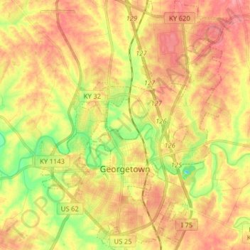
Name: Georgetown topographic map, elevation, terrain.
Location: Georgetown, Scott County, Kentucky, 40324, United States (38.17693 -84.60252 38.27794 -84.50419)
Average elevation: 265 m
Minimum elevation: 221 m
Maximum elevation: 296 m
Thank you for supporting this site ❤️
Make a donation
Make a donation
Other topographic maps
Click on a map to view its topography, its elevation and its terrain.