
Make a donation
Erongo Region topographic map
Click on the map to display elevation.
Make a donation
About this map
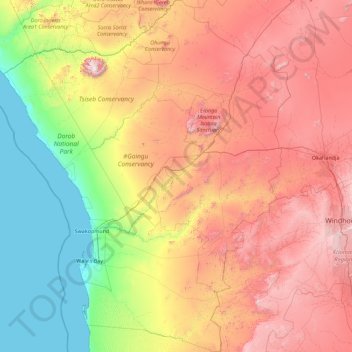
Name: Erongo Region topographic map, elevation, terrain.
Location: Erongo Region, Namibia (-23.80888 13.63272 -20.49159 16.55596)
Average elevation: 867 m
Minimum elevation: 0 m
Maximum elevation: 2,454 m
Make a donation
Other topographic maps
Click on a map to view its topography, its elevation and its terrain.
Make a donation
Make a donation
Windhoek
Windhoek has over 300 sunny days per year. It experiences a hot semi-arid climate (BSh) according to Köppen climate classification as the annual average temperature is above 18 °C (64 °F). The temperature throughout the year would be called mild, due to altitude influence. The annual average high and low…
Average elevation: 1,679 m
Make a donation
Tsumeb
Near the town are two large sinkhole lakes, Lake Otjikoto and Lake Guinas ("Gwee-nus"). Guinas, at about 500 m in diameter, is somewhat larger in area than Otjikoto. A pioneering documentary movie about scuba diving in these lakes was made by Graham Ferreira in the early 1970s. The depths of the lakes are…
Average elevation: 1,310 m
Make a donation
Make a donation
Khorixas
Namibia > Kunene Region > Khorixas
The regional hospital and some other regional offices are located in Khorixas, though the capital of the Kunene Region is Opuwo. Khorixas has a landing strip nine kilometers east of town parallel to the C39 main road. The Runway Numbers are 09/27 and elevation is 3320 feet.
Average elevation: 974 m
Make a donation
Rehoboth
Rehoboth is a town in central Namibia just north of the Tropic of Capricorn. Located 90 kilometres (55 miles) south of the Namibian capital Windhoek, Rehoboth lies on a high elevation plateau with several natural hot-water springs. It receives sparse mean annual rainfall of 240 millimetres (9.4 in), although…
Average elevation: 1,408 m
Make a donation
Hoachanas
Hoachanas is situated on Namibia's Central Plateau in an Acacia tree and shrub savanna typical for the Kalahari. The area has an elevation of 1,200 to 1,500 metres (3,900–4,900 ft), the average annual rainfall is 200 to 250 millimetres (7.9–9.8 in). The settlement is cut by the !Guwisib River, a tributary…
Average elevation: 1,261 m
Make a donation
Make a donation
Windhoek
Windhoek has over 300 sunny days per year. It experiences a hot semi-arid climate (BSh) according to Köppen climate classification as the annual average temperature is above 18 °C (64 °F). The temperature throughout the year would be called mild, due to altitude influence. The annual average high and low…
Average elevation: 1,679 m
Make a donation
Make a donation
Make a donation
Make a donation
Katima Mulilo
Namibia > Zambezi > Katima Mulilo
Katima Mulilo has a hot semi-arid climate (Köppen BSh), bordering on a dry-winter humid subtropical climate (Cwa). Almost all rainfall occurs from November to March, when the weather is hot and humid although substantially moderated by altitude. In the long dry season between April and October the weather…
Average elevation: 968 m
Make a donation
Make a donation
Khorixas
Namibia > Kunene Region > Khorixas
The regional hospital and some other regional offices are still located in Khorixas, though the capital of Kunene Region is Opuwo. Khorixas has a landing strip nine kilometers east of town parallel to the main road C39. The Runway Numbers are 09/27 and elevation is 3320 feet.
Average elevation: 974 m
Make a donation
Make a donation
Make a donation