
Make a donation
Salar del Hombre Muerto topographic map
Click on the map to display elevation.
Make a donation
Salar del Hombre Muerto
Salar del Hombre Muerto lies at 4,300–4,100 metres (14,100–13,500 ft) elevation in the southern Puna and is surrounded by mountains, including volcanoes and summits reaching elevations that exceed 5,000 metres (16,000 ft). The Galán volcano lies just south of Hombre Muerto and has produced large ignimbrites, while 5,252 metres (17,231 ft) high Cerro Ratones is located on the northeastern margin; additional volcanoes and faults exist in the area of Hombre Muerto. Farther west-southwest lies the long Salar de Antofalla while the Salar de Ratones and Salar de Diablillos are found north-northeast and northeast from Salar del Hombre Muerto. 302 kilometres (188 mi) farther east lies the city of Salta.
Make a donation
About this map
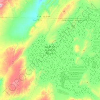
Name: Salar del Hombre Muerto topographic map, elevation, terrain.
Average elevation: 4,089 m
Minimum elevation: 3,692 m
Maximum elevation: 5,055 m
Make a donation
Other topographic maps
Click on a map to view its topography, its elevation and its terrain.
Monte Pissis
Argentina > Catamarca > Municipio de Fiambalá
A 1994 Argentine expedition claimed —using GPS technology available at the time— that the elevation of Monte Pissis was 6,882 m (22,579 ft), higher than Ojos del Salado. Ten years later, with the use of higher precision systems, several other surveys proved that those measurements were inaccurate: in 2005,…
Average elevation: 6,465 m
Make a donation