
Thank you for supporting this site ❤️
Make a donation
Make a donation
Granges Feuillet topographic map
Click on the map to display elevation.
Thank you for supporting this site ❤️
Make a donation
Make a donation
About this map
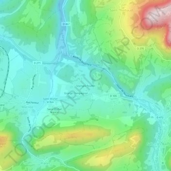
Name: Granges Feuillet topographic map, elevation, terrain.
Average elevation: 426 m
Minimum elevation: 280 m
Maximum elevation: 817 m
Thank you for supporting this site ❤️
Make a donation
Make a donation
Other topographic maps
Click on a map to view its topography, its elevation and its terrain.
Fort Saint-André
France > Bourgogne-Franche-Comté > Jura > Salins-les-Bains
Le fort est bâti sur le mont Saint-André, qui domine l'ouest de Salins, à une altitude de 604 mètres.
Average elevation: 435 m